Southwest US faces heavy rain and flash-flood threat
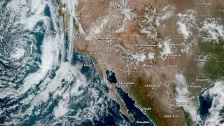
A deep low pressure system is expected to pull tropical moisture into the southwestern United States, bringing heavy rain and thunderstorms from October 21 to 23. Forecasters have marked parts of Southern California and the Southwest for a slight risk of excessive rainfall, while central and eastern Arizona face a slight risk of severe storms. Localized downpours could reach about 51 mm per hour where storms repeatedly form over mountainous terrain.
A potent Pacific low-pressure area is expected to pull tropical air inland, leading forecasters to identify southern California and the Southwest as possible areas of excessive rain on October 21. The Los Angeles metro area, western Transverse Ranges and coastal mountains north of Point Conception were raised to a slight excessive-rainfall category.
Central and eastern Arizona may see severe thunderstorms. Phoenix's nearby foothills and higher ground could collect about 38–64 mm, whereas lower desert areas probably remain under 25 mm; slow-moving or repeating mountain storms could generate local rates around 51–64 mm/h.
The weather could affect residents, travelers and outdoor workers across Southern California and Arizona, particularly near burn scars, canyons and dry washes where runoff may rise quickly. Urban flooding may disrupt roads and local services, while severe storms could bring damaging winds, hail and isolated tornadoes. Emergency managers and residents may need to track forecasts and avoid vulnerable terrain during the heaviest rain.