Hurricane Isaias Threatens Northern Gulf Coast with Dangerous Storm Surge
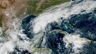
Hurricane Isaias is forecast to bring dangerous storm surge of 1.5–2 m along parts of the northern U.S. Gulf Coast, including Mobile Bay, if the highest surge arrives at high tide. The storm is expected to produce 75–180 mm of rain from southeastern Louisiana to Florida's Big Bend, with isolated totals near 380 mm. Isaias is projected to make landfall late Friday or early Saturday and could strengthen to near Category 2 before weakening slightly.
Expanded Detail
EXPANDED:
Isaias became a hurricane early on October 8 after Air Force Reserve reconnaissance measured sustained winds near 120 km/h. As of 18:00 UTC, its
Expanded detail and Context are AI-generated analysis; the linked article remains the authoritative source.
Related stories
Tropical Storm Isaias intensifying rapidly as it approaches U.S. Gulf Coast Friday · Extreme weather
Gulf Storm System Intensifies Into Hurricane Threat for U.S. Coast · Extreme weather
This summary is Al-enhanced to contain extended analysis and broader social context. The original is {NAME); the linked article is the authoritative source. Original headline: “Life-threatening storm surge of up to 2 m (7 feet) forecast as Hurricane Isaias approaches U.S. Gulf Coast.” Browse more stories.